Monahan Outdoor Education Center
This document is a summary of the history of the Monahan Outdoor Education Center based primarily on Imhof (1994, see reference below).
About the Monahan Outdoor Education Center
In 1988, Dr. and Mrs. William J. Reals of Wichita donated the land to the PSU Biology Department in memory of Mrs. Reals' father, the late Francis A. Monahan. Monahan was the son of a mining engineer from Scotland, and he used the valuable skills he learned from his father in the coal fields in Cherokee and Crawford Counties.
In the early 1950s, Monahan bought the 156 acre tract of land from the Commercial Fuel Company because he knew there was still a lot coal there and a lot of coal dust in the washings and thought some of it might be salvaged. Monahan was also interested in seeing the land restored. He was always concerned about the impact mining had on the land. He was even appointed by the governor to serve on a state commission that studied the environmental impact of strip mining.
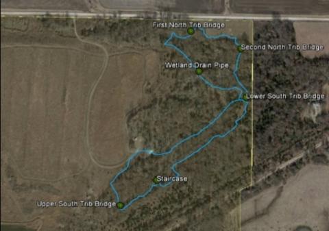
The initial development of the Monahan Outdoor Education Center included a barn and a caretaker's quarters (mobile home). The barn houses maintenance equipment and supplies including a tractor and implements, firefighting equipment, and related materials for managing the site. Rural water was provided later. In 2001, the Reals Pavilion was completed as a shelter for visitors. The Coal Creek Nature Trail system was also developed on the east side of the property.
A modern pit toilet has been constructed adjacent to the pavilion by the PSU College of Technology, and a wetland area was created south of the grassed mound (with funding from the Natural Resource Conservation Service).
Background
The Monahan Outdoor Education Center was developed on an abandoned mine land site located in southeast Crawford County, approximately one-half mile north and one-half mile east of the town of Cherokee (NE 1/4 of S17, T31S, R24E). The Monahan was underlain by the Cabiness Formation. This formation is Middle Pennsylvanian in age, around 200 million years old and is comprised of a succession of shale, limestone, sandstone, and coal beds.
The site was shaft mined (underground mined by room and pillar method) in the period 1910-1920. The coal seam was the Weir-Pittsburg coal bed, about 100 feet below ground surface and approximately three feet thick. The same area was strip mined in the mid-30s until the early-40's. The strip-mined coal was the Mineral coal seam, only 25 feet below the ground and was 18 inches thick.
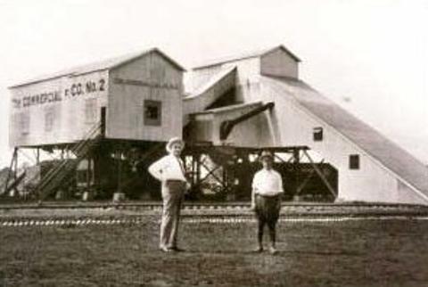
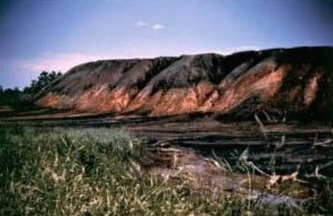
At the time of strip mining, the mine was called Commercial Mine #10. [photo below on the far left of another local mine; source unknown] The mine was also the site of a tipple. A tipple is the coal processing plant where mine cars were "tipped" and emptied of their coal. Coal from Commercial Mine #10 and other mines in the vicinity was brought to the tipple for washing and screening. The wash plant was located near the railroad tracks on the south side of the area. It was shaped somewhat like a grain elevator. The coal was conveyed to the top, and then passed through various sizes of shaker screens, all the while being washed with water. The sediment-laden wash water was then conveyed into a settlement pond, sometimes called a slurry pond. The sand-sized sediment in this slurry eventually would settle out, and the water would be reused for washing. The sediment in the pond accumulated to a depth of about six feet and covered approximately 30 acres with about 50 percent of the sediment being coal fines.
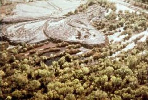
The term gob refers to all other waste material separated from the coal but too large to be carried away in the wash water. This gob was hauled to a dump area to the northwest of the tipple and eventually covered seventeen acres to a height of 20 to 30 feet. The big pile of gob soon eroded into hills and valleys.
The gob pile at the Monahan contained an abundance of pyrite and virtually no limestone. Pyrite is found within shale, sometimes running vein like between layers of the rock. When this is buried beneath the earth's surface it is stable, but when it is exposed to oxygen either from the atmosphere or from water, pyrite oxidizes.
According to local residents, the gob pile at the Monahan burned for many years. Gob often burns because of spontaneous combustion, the heating and slow combustion of the coal and coal materials. This is initiated by the absorption of oxygen. When air leaks through the coal and shale material and supplies the needed oxygen for combustion, and conditions do not allow dissipation of heat, there is a subsequent rise in temperature. This rise in temperature ignites the coal and shale materials.
Evidence that spontaneous combustion had occurred at the Monahan was present at the time of study and investigation. A substance called "red dog" was found over much of the gob pile area. Red dog is a material of reddish-brown color resulting from the combustion of shale and other mine wastes.
Neither the slurry pond nor the gob pile revegetated because of these extreme conditions. Grasses, shrubs, and trees are not tolerant of these conditions, conditions that cause not only a very low pH but also a high concentration of metals. After years of continuous oxidation of the pyrite and the burning out of the exposed coal and shales, the surface was desolate.
Pre-Reclamation Conditions
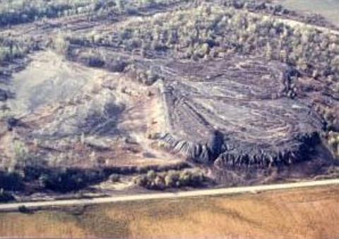
Local residents called the abandoned Commercial Mine #10 Devil's Mesa and The Desert. Still, without vegetation after 40 years of lying idle, the Monahan looked like the moon. There were deep ravines eroded in the surface and small pools of red water. The hydroxide crust made the surface crunchy and mineral salts crystallized into pure whites and yellows. Numerous fossils could be found; people liked to walk there, drive off-road vehicles there, and take target practice against the gob pile. It was not a pretty site, but its strangeness made it acceptable.
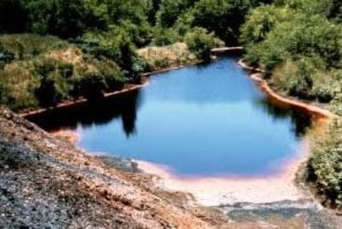
Under SMCRA (the Surface Mining Control and Reclamation Act), the Monahan became eligible for abandoned mine lands (AML Program) funds. The site presented a hazard to local residents, as well as being an eyesore. A water sample taken in the preliminary study from the tributary running along the north boundary of the property had a pH of 2.1. This tributary ultimately empties into Brush Creek, which was void of aquatic life for a mile downstream. The gob pile was the source of the toxic wastes and highly acidic material that contaminated the water in the tributary and the area around it.
When the Monahan site was first assessed for reclamation there were approximately 80 acres of barren refuse, coal slurry, and mine spoils. Between the gob pile and the dumps that separated a large strip pit, there were several small acid pits, and on the southern border, the remains of the coal processing plant still lay close to the railroad tracks.
At the time of the assessment, weathering, and erosion had been at work for about 40 years, leaving a number of steep and unstable slopes. There was no vegetation because of the acid conditions and because an iron hydroxide crust had formed on the gob pile making it impossible for plant roots to penetrate the surface and become established. The slurry pond was east of the gob pile and was also void of vegetation. A dike had been built around the slurry pond to keep the slurry in place, and this dike and everything east to the property fence had revegetated.
The materials underlying the gob pile included a deep residual clay soil extending from the ground surface to a depth of about 15 feet. Under the clay soil was a weathered clay shale, brown to light gray in color, which extended from about 15 to 25 feet below the ground surface. Underlying the weathered shale, a succession of shales, sandstones, and thin limestones occurred. This bedrock strata also contains a few coal layers at 25 to 30 foot intervals.
A concentrated seep issuing from the base of the gob pile on the north side was estimated to be running about 0.5 gallons per minute and appeared to be the beginning of the tributary draining the north side of the Monahan site.
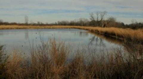
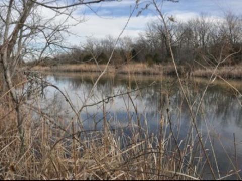
On the western boundary of the area was a large strip pit lake. Surface water running off of the gob pile gathered into several small pits east of this large strip pit lake. The water in the small pits was highly acidic, pH 2.2 to 2.6. There were a few vegetated dumps between the small acid pits and the large pit. These dumps and the slope of the land kept this large pit from being affected by the acid drainage.
Surface water infiltrated the gob and formed several small acid pits, while the remaining surface water found its way into either of the two tributaries that eventually drained off-site. The drainage tributary on the north received surface water runoff and water from the seep. The drainage ditch on the south side received surface water runoff and overflow from Razor pit. Cattails were growing in the marshy area at the south end of the large pit, approximately 2.7 acres in area. The marsh conformed into the south drainage ditch, which continued to support the growth of cattails until it received too much acid runoff from the gob pile for them to tolerate. The two streams travel east and merge just off-site. From there the water flows into a tributary of Brush Creek which was void of life from below the site to its confluence with Brush Creek two miles east.
The Monahan Reclamation
The Monahan was reclaimed under an interagency agreement between the Office of Surface Mining and the Soil Conservation Service. Funds were provided through the Rural Abandoned Mined Land Program (RAMP), Public Law 95-87 Sec. 406, and the Soil Conservation Service provided the design and construction to begin reclamation of the Monahan site (Interagency Agreement # J6601019, 1980).
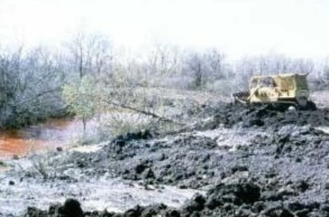
Reclamation began in 1984 and ended eight months later in the spring of 1985. According to the Soil Conservation Service, the sequence of events were:
- Construct an erosion control dam.
- Cover exposed concrete, cleanup the tipple site, and construct diversions.
- Remove brush from acid pit area.
- Pump acid water from small pits and spray over gob pile.
- Fill acid pits with gob from reshaping.
- Construct main drainage ditch on west side of site.
- Shape gob pile to 3% slope to the east.
- Place one foot of topsoil over non-productive areas.
- Place one foot of crushed limestone over 34 acres which was underlain with gob material (17,000 tons used).
- Place one foot additional topsoil over crushed rock.
- Construct five tile outlet terraces two feet below ground surface.
- Disc, fertilize, and plant oats for a cover crop.
- Construct a fence.
- Plant trees, shrubs, and grass in spring of 1985.
The topsoil referred to was actually mine spoil from spoil dumps that were between the gob pile and the large pit. Upon completion of these events, the gob pile was reshaped and the tile drainage system was in place.
The tile drainage system was put on a foot of mine spoil then topped with a foot of limestone and another foot of mine soil. Total depth from surface to tile drainage system is two feet. The tiles direct surface water away from the gob and into a central drain outlet. The drainage system along with the limestone and mine spoil cap and seeding of native grasses stabilized the top of the gob pile and helped to deter erosion.
The gob pile was flattened from a 1 1/2:1 slope to a 3:1 slope, making the final grade 2%. The gob pile was then terraced into five ridges with the height not to exceed nine inches before compaction with five terrace outlets connected to a main conduit. The main conduit starts out with a 10" diameter PVC pipe and changes to a 12" diameter PVC pipe at terrace #3. From terrace #1 to terrace #5, the main conduit has a 3% grade and then turns 45 degrees into a 6% grade. Another 45 degree turn brings the end of the conduit to the north side of the Monahan east of the pavilion road. At the valley of each terrace, rising about 2.5 feet above the ground, is a pipe 8" in diameter that is connected two feet underground with the main conduit. The part of the pipe that is exposed above ground is perforated. These pipes were installed in trenches that had been cleared of vegetative matter for at least an 8" diameter from the pipe (USDA 1983). The trenches are supposed to encourage surface waters to run into the tile outlets and keep the water from contacting buried waste material.
The grasses planted were a mixture of native species. This included Little Bluestem, Big Bluestem, Sideoats Grama, Wheatgrass, Switchgrass, Buffalograss, Prairie Coneflower, Purple Prairie Clover, and Prairie Sunflowers. Planting the native mixture was a fairly new venture as most reclamation projects at this time were planted to pasture. Trees and shrubs planted were Pin Oak, Russian Mulberry, Walnut, Pines, Sumac, Autumn Olive, Plum, and Cherry.
Post-Reclamation Conditions
In the spring of 1987, two years after the Monahan site had been planted with a native grass mixture, the dominant plant was sweet clover. Sweet clover was not in the original seed mixture but must have invaded from neighboring fields. The clover grew to a height of five feet tall over much of the site.
The shrubs and woody plants did not fare well; lack of water and wildlife damage killed most of these. By the next growing season in 1988, the native grasses became well established. Deer used the area, as well as many smaller mammals. A variety of birds could be found including large coveys of quail.
The tributary on the south, running from the wetland to the east, had a pH of 5.4 and was clear during periods of high precipitation but was yellow during periods of low precipitation. The tributary draining the south side of the study area starts as overflow from the large pit and flows east. Continuing east, it receives runoff from the south side of the recontoured gob pile and from the naturally revegetated portion of the Monahan site on the east end of the study area. The tributary then turns north and travels approximately 1000 feet to meet with the tributary which drains the north side of the Monahan site. The tributary on the north side starts at the base of the reclaimed gob pile, beginning as a seep, and also flows east. Water from the tile drainage system is added to the tributary as well as surface water from the study area itself and from the field across the road north of the study area. There is also an intermittent tributary draining the old slurry pond area on the east fourth of the property.
Monahan Documents
- Reals Reconstruction. 1983. Construction Specification. Soil Conservation Service, Kansas.
- United States Department of Agriculture, Soil Conservation Service. 1981. Environmental Assessment-Reals Abandoned Mine Land Project, Crawford county, Kansas.
- United States Department of Agriculture, Soil Conservation Service. 1981. Geology Report on the Reals Abandoned Coal Mine Area, Crawford County, Kansas.
- Joseph A. Arruda. 2003. Final Report: Remediation Water Quality Survey of Reclaimed Abandoned Mine Land.
Monahan Theses
- Vickers, Jeff. 1989. Vegetative Analysis of the Monahan Reclaimed Mined Land Area. Master's Thesis. Pittsburg State University, Pittsburg, Kansas. [Thesis Advisor: Dr. Ralph Kelting)
- Imhoff, Sally. 1994. A Post-Reclamation Water Quality Assessment of the Monahan Outdoor Education Center. Master's Thesis. Pittsburg State University, Pittsburg, Kansas. (Thesis Advisor: Dr. Joseph A. Arruda)
- Yates, Karen. 1996. The Evaluation of Two Types of Multivariate Analyses Applied to Grassland Vegetation Data from a Reclaimed Mine Area in Southeast Kansas, USA. Master's Thesis. Pittsburg State University, Pittsburg, Kansas. (Thesis Advisor: Dr. Joseph A. Arruda)